John Senex was born in Ludlow, the son of a Shropshire
gentleman. In 1695 he was apprenticed to Robert Clavell, a
London bookseller and member of the Stationers’
Company, under whom he mastered engraving and
printing. His earliest publication, in 1702, was
‘Short Discourses upon the Whole Common Prayer.’
On completion of his apprenticeship he too became a
bookseller and a printer. Later, in conjunction with
mapmakers such as Charles Price and Jeremiah Seller,
he became a publisher and mapmaker. Over the next few
years his cartographic ventures included a world atlas,
maps of continents and countries, county maps, town plans
and even the production of a number of globes both
terrestrial and celestial. In 1728 he was made a Fellow of the Royal Society of London and later also made
Geographer to Queen Anne. Although he published many important maps he is best known for his road
maps. To that end he was clearly an asset to travellers, the numbers of whom were increasing markedly, on
the post roads of the country. There was now a demand for a small, easy to carry, pocket version to replace
the rather weighty, cumbersome set of Ogilby’s earlier road maps. Senex saw an opportunity and around
1718 made his first foray in the area when he published ‘A Map of England with the Roads by John Senex’.
However, it was in 1719 that he published his most memorable work. It was octavo, in two volumes, and a
miniature corrected edition of Ogilby’s ‘Britannia’. It was entitled ‘An Actual Survey of all the Principal Roads of
England & Wales; described by One Hundred Maps from Copper Plates... First perform’d & published by John Ogilby, Esq;
And now improved, very much corrected, & made portable by John Senex. In 2 Vol. London 1719’ and sold at the Globe,
in Salisbury Court, Fleet Street. Three more editions followed that year. Each edition consisted of 100 maps
that were numbered in the bottom right hand corner of each map. In 1742, two years after his death his
widow, Mary Senex, issued a copy with the same title but included the words ‘The Second Edition’ which had
the maps printed on both sides of the sheet, with plate numbers on both sides at the top. She also issued a
‘The Third Edition’ in 1743 and ‘The Fourth Edition’ in 1748. In 1757 ‘The Survey’ was republished by John Bowles,
with changes, and a new title ‘The Roads through England delineated or Ogilby’s Survey. Revised, Improved and
reduced to a size portable for the pocket By John Senex FRS’. Other editions in 1762, 1768, 1780, 1792 all carried the
new title, albeit with different publishers. Senex’s maps also appeared in a French edition in 1759, while
others appeared, sometimes in part, in Thomas Kitchen’s ‘Post-Chaise Companion’ 1767, Thomas Jeffery’s
‘Itinerary’ 1775 and, it is believed, ‘The Universal Magazine of Knowledge & Pleasure’.
The layout of the road maps, portrayed as strips of unwinding scrolls, along with directional compass, were
generally in the same format already described on Ogilby’s map. However, they were not as well executed as
those by Thomas Gardner whose pocket road map, also published in 1719, reflected a much closer copy of
Ogilby’s. Furthermore, there is no evidence that Senex’s statement that his road map was ‘And now improved,
very much corrected’ was true. It was clearly a marketing ploy to attract sales. Moreover, because of his status,
and his Royal Society connections, he was able to reach out to a wider audience. Thus, he published extra
editions to satisfy the growing demand. On the other hand, the lesser known Gardner with, it could be said, a
more visually appealing pocket road map managed only to publish one edition. In reality Senex’s only
improvement rested fairly and squarely on its useful size.
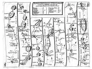
Senex’s three plate/page numbers that covered the Rutland area start at Plate 45 (High Barnet, Hatfield,
Baldock, Biggleswade, St Neots to Oakham). It is the road map illustrated and entitled ‘The Road from London
to St Neot’s in Hunt sh Continued to Okeham in Rutland sh Commencing at Barnet in the Holy Head Road’.
The two other maps were namely: Plate 47 (St Albans, Luton, Bedford, Wellingborough, Kettering to
Oakham) and Plate 48 (Oakham, Melton Mowbray, Nottingham, Mansfield, Rotheram to Barnsley).
Each map measures about 8¼ inches (210mm) across with a top to bottom measurement of
6¼ inches (160mm).


Langham Village History Group ~ © 1996 - 2025


John Senex c1678-1740 by Anthony Wright


John Senex was born in Ludlow, the son of a Shropshire
gentleman. In 1695 he was apprenticed to Robert Clavell, a
London bookseller and member of the Stationers’
Company, under whom he mastered engraving and
printing. His earliest publication, in 1702, was
‘Short Discourses upon the Whole Common Prayer.’
On completion of his apprenticeship he too became a
bookseller and a printer. Later, in conjunction with
mapmakers such as Charles Price and Jeremiah Seller,
he became a publisher and mapmaker. Over the next few
years his cartographic ventures included a world atlas,
maps of continents and countries, county maps, town plans
and even the production of a number of globes both
terrestrial and celestial. In 1728 he was made a Fellow of the Royal Society of London and later also made
Geographer to Queen Anne. Although he published many important maps he is best known for his road
maps. To that end he was clearly an asset to travellers, the numbers of whom were increasing markedly, on
the post roads of the country. There was now a demand for a small, easy to carry, pocket version to replace
the rather weighty, cumbersome set of Ogilby’s earlier road maps. Senex saw an opportunity and around
1718 made his first foray in the area when he published ‘A Map of England with the Roads by John Senex’.
However, it was in 1719 that he published his most memorable work. It was octavo, in two volumes, and a
miniature corrected edition of Ogilby’s ‘Britannia’. It was entitled ‘An Actual Survey of all the Principal Roads of
England & Wales; described by One Hundred Maps from Copper Plates... First perform’d & published by John Ogilby, Esq;
And now improved, very much corrected, & made portable by John Senex. In 2 Vol. London 1719’ and sold at the Globe,
in Salisbury Court, Fleet Street. Three more editions followed that year. Each edition consisted of 100 maps
that were numbered in the bottom right hand corner of each map. In 1742, two years after his death his
widow, Mary Senex, issued a copy with the same title but included the words ‘The Second Edition’ which had
the maps printed on both sides of the sheet, with plate numbers on both sides at the top. She also issued a
‘The Third Edition’ in 1743 and ‘The Fourth Edition’ in 1748. In 1757 ‘The Survey’ was republished by John Bowles,
with changes, and a new title ‘The Roads through England delineated or Ogilby’s Survey. Revised, Improved and
reduced to a size portable for the pocket By John Senex FRS’. Other editions in 1762, 1768, 1780, 1792 all carried the
new title, albeit with different publishers. Senex’s maps also appeared in a French edition in 1759, while
others appeared, sometimes in part, in Thomas Kitchen’s ‘Post-Chaise Companion’ 1767, Thomas Jeffery’s
‘Itinerary’ 1775 and, it is believed, ‘The Universal Magazine of Knowledge & Pleasure’.
The layout of the road maps, portrayed as strips of unwinding scrolls, along with directional compass, were
generally in the same format already described on Ogilby’s map. However, they were not as well executed as
those by Thomas Gardner whose pocket road map, also published in 1719, reflected a much closer copy of
Ogilby’s. Furthermore, there is no evidence that Senex’s statement that his road map was ‘And now improved,
very much corrected’ was true. It was clearly a marketing ploy to attract sales. Moreover, because of his status,
and his Royal Society connections, he was able to reach out to a wider audience. Thus, he published extra
editions to satisfy the growing demand. On the other hand, the lesser known Gardner with, it could be said, a
more visually appealing pocket road map managed only to publish one edition. In reality Senex’s only
improvement rested fairly and squarely on its useful size.
Senex’s three plate/page numbers that covered the Rutland area start at Plate 45 (High Barnet, Hatfield,
Baldock, Biggleswade, St Neots to Oakham). It is the road map illustrated and entitled ‘The Road from London
to St Neot’s in Hunt sh Continued to Okeham in Rutland sh Commencing at Barnet in the Holy Head Road’.
The two other maps were namely: Plate 47 (St Albans, Luton, Bedford, Wellingborough, Kettering to
Oakham) and Plate 48 (Oakham, Melton Mowbray, Nottingham, Mansfield, Rotheram to Barnsley).
Each map measures about 8¼ inches (210mm) across with a top to bottom measurement of
6¼ inches (160mm).


Langham Village History Group ~ © 1996 - 2025